

Article by Capt. Steve Katz
 What time is it?
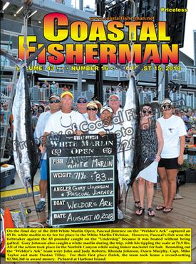
Congratulations to the all of the participants and winners of this year’s White Marlin Open. The challenge of running offshore for consecutive days in all weather conditions is a lot of work for the crew, and catching a prize winning fish is even more difficult. Great job to all!
We wish all crew and anglers good luck in The MidAtlantic next week.
Let’s review a popular topic during fishing tournaments - time of day.
While many crew members do not wear a watch while fishing, keeping track of the correct time is even more critical during a tournament. With so many electronic gadgets supplying the time, we expect it to be correct and synchronized between all devices. A marine chartplotter or GPS, as with most modern timekeeping devices, it needs to be properly programmed to your location for the proper time zone and the use of day light savings time. Many of us on a boat have come to rely on the time displayed on the chartplotter or related device for being the proper time.
How does a GPS chartplotter know the correct time?
Chartplotters receive the time from GPS satellites. In addition to longitude, latitude, and altitude, the Global Positioning System (GPS) provides a critical fourth dimension – time. Each GPS satellite contains multiple atomic clocks that contribute very precise time data to the GPS signals. GPS receivers decode these signals, to the UTC standard, and effectively synchronize each GPS receiver to the world’s atomic clocks. This enables users to determine the exact time to within 100 billionths of a second, without the cost of owning and operating atomic clocks.
The manufacturers of these GPS receivers generally automate the device’s time settings, allowing it to be automatically adjusted based on your GPS location, just like a smart phone. Seems like a good idea, right? Well many of the devices may be too smart. They know when your boat moves into a different time zone or time of year and even when it has exceeded the coastal 12-mile territorial waters of the USA. Once beyond the 12-mile coastal limit, the chartplotter often automatically eliminates the daylight savings time (subtracting one hour in the summer) on the way to the distant fishing grounds and then adding back the one hour on the return trip to port, at that same 12-mile territorial water limit.
The best way to deal with this issue and synchronize the vessels time to the same time zone at port, is to manually configure the time zone (or offset) of your GPS display systems. Often, the time of day menu on the chartplotter has a setting for display format and offset adjustment from UTC. Keeping the same time at sea and at port will also allow your calculated ETA to be correct. Here in Maryland during the summer, the time zone is -4 (minus 4 hours) from UTC.
The Garmin chartplotter devices seem to need manual time zone configuration more than other brands since they default to the automatic time zone settings for simplicity. The steps below are for the most popular current Garmin devices. Other brands may be similar.
•Start from Home screen
•Select Configure/Setting
•Select Preferences
•Select Units
•Select Time
•Select Time Zone
•Select Custom
GMT or UTC?
Many of us once referenced time based on Greenwich Mean Time (GMT).
GMT is actually a time zone in England that also happens to be the same as UTC. The Universal Time Coordinated (UTC) is an international standard referenced around the world. UTC is an atomic timescale; it usually has 86,400 seconds per day but is kept within 0.9 seconds of the mean solar time by the introduction of occasional leap seconds. If you are curious, there are currently 37 worldwide time zones, with some zones having 30 or 45 minute intervals as compared to the traditional 1 hour differentials based on 1 hour per 15 degrees longitude.
If you are using a digital video camera or still camera (especially in tournaments), be sure you check and set the devices time so the images timestamp is correct with the time zone and season.
Setting your ships clocks and devices to the correct time will allow you to be sure you start and stop fishing at the correct time, fill out the catch reports properly and have the correct estimated time of arrival (ETA) for your trip.
Captain Steve Katz is the owner of Steve’s Marine Service and holds NMEA, AMEI and NMEA2000 certificates along with ABYC Master Technician certification and factory training from many manufacturers. To reach Steve, call (631) 264-1600.